Call
Home LiDAR Surveys Thermal Inspection Photogrammetry Aerial Inspection Multispectral / Ag Videography & FPV Get a Quote
Call or Text (281) 799-3259
Email (.KMZ / Boundaries) curtis@densmoredroneservices.com
DJI Zenmuse L3 Commercial LiDAR Drone Surveying Houston and East Texas
Aerial LiDAR Survey • Greater Houston & East Texas

Survey-Grade LiDAR
Drone Surveys

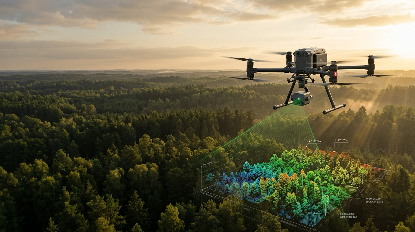
The DJI Zenmuse L3 payload delivers up to 16 returns per pulse, bare-earth terrain models, and centimeter-accurate point clouds across Greater Houston and East Texas. From pre-construction site development and civil topography to utility corridors and timber acreage.

Limited-Time Survey Special

Promotional Package: Aerial LiDAR

High-density 250+ Pts/m² survey powered by the flagship DJI Zenmuse L3 sensor.

$15 / Acre
Minimum project fee: $2,250 (Includes up to 150 contiguous acres)
Additional acreage billed at $15/acre
250+ Points/m² Density DJI Zenmuse L3 Payload Up to 16 Returns / Pulse Houston, Southeast & East Texas
Industry Benchmark: Traditional manned aircraft and manual ground surveying typically cost $50–$150+/acre with weeks of scheduling delays. Our survey-grade deliverables start at just $15/acre with rapid same-week flight dispatch.

Included Deliverables

  • Classified Point Cloud (.LAS / .LAZ)
  • Bare-Earth Digital Terrain Model (DTM GeoTIFF)
  • 1-Foot or 2-Foot Elevation Contours (.DXF / CAD-ready)
  • Calibration & Accuracy Report (Calibrated via on-site GNSS base data post-processed through NRCan CSRS-PPP)
Claim Promo Quote

Qualification Criteria & Disclaimers

  1. 1
    Contiguous Site: Site must be a single, contiguous parcel accessible from 1–2 launch locations with legal Visual Line of Sight (VLOS).
  2. 2
    Airspace & Clearances: Site must be located in FAA Class G (uncontrolled) airspace or eligible for automated FAA LAANC authorization (not in restricted, prohibited, or zero-grid flight zones).
  3. 3
    Terrain & Canopy: Standard rolling, open, or moderate deciduous forest terrain. Extreme vertical bluffs, active quarry walls, or hazardous industrial sites require a custom quote.
  4. 4
    Geodetic Control & Legal Surveying: Includes absolute accuracy calibrated via on-site static GNSS base observations post-processed through NRCan CSRS-PPP (Precise Point Positioning).
    Notice: This service provides high-accuracy remote sensing and geospatial data collection. It does not constitute a legal boundary survey and does not include a licensed Professional Land Surveyor (PLS) seal unless arranged separately.
  5. 5
    Weather Rescheduling: Operations are subject to safe flying conditions (winds under 20 mph, no active rain, cloud ceilings above flight altitude). Weather delays will be rescheduled at no additional fee.
  6. 6
    Travel Radius: Standard pricing applies within 100 miles of Spring, TX. Projects beyond this radius incur standard mileage/travel expense.
250+
Points/m² Density
16 Returns
Canopy Penetration
CSRS-PPP
1cm Geodetic Accuracy
100 Miles
Zero Travel Surcharge
CAD & GIS
.LAS, .DXF, DTM GeoTIFF
Part 107
FAA Certified & Insured
Commercial Drone Survey & Industrial Inspection

Survey-Grade Accuracy & Comprehensive Aerial Insights

From dense-canopy LiDAR point clouds to high-resolution 2D orthomosaics and calibrated radiometric thermal thermography, Densmore Drone Services delivers commercial-grade aerial data across Greater Houston and East Texas. Powered by the flagship DJI Zenmuse L3 payload (up to 16 returns per pulse), 4/3 CMOS photogrammetry sensors, and high-sensitivity radiometric infrared cameras.

.LAS / .LAZ

Classified Point Cloud

Dense 3D point clouds captured at 250+ pts/m² with up to 16 returns per pulse. Rigorously classified into ground, low/medium/high vegetation, buildings, and structures for engineering and GIS software.

DTM GeoTIFF

Bare-Earth Digital Terrain Model

Digital elevation rasters stripped of all vegetation and surface clutter to reveal true ground elevation. Essential for civil grading, overland drainage analysis, and earthwork planning.

.DXF, .DWG, .SHP

Bare-Earth Topographic Contours

Smooth, CAD-ready 1-foot or 2-foot index and intermediate elevation contour polylines. Ready for immediate import into AutoCAD Civil 3D, Carlson Survey, or MicroStation.

.SHP, .DXF, PDF

Hydrology & Drainage Flow Maps

Model surface runoff pathways, flow accumulation channels, detention basins, and watershed boundaries to identify natural drainage corridors and flood risks before breaking ground.

PDF + Heatmap

Stockpile & Cut/Fill Volumetrics

High-accuracy volumetric calculations for material stockpiles, detention ponds, and mass grading. Includes volume reports and colorized cut/fill differential heatmaps.

CHM & Structure Grid

Canopy Height Model & Forest Structure

Harnessing the 16 returns per pulse of the Zenmuse L3, we measure individual tree heights, canopy closure percentages, and forest biomass for timber appraisal and powerline clearance.

GeoTIFF, ECW & CAD Overlay

High-Res 2D Orthomosaics & Aerial Imaging

Sub-centimeter resolution aerial orthophotography captured with large 4/3 CMOS 20MP mechanical shutter optics. Delivers geometrically corrected, measurable aerial base maps for civil site planning, construction progress documentation, and CAD overlays.

FLIR RJPEG & Thermal PDF

Radiometric Thermal & Infrared Inspection

Calibrated radiometric thermal thermography for commercial flat-roof moisture detection, solar panel hotspot and cell failure audits, electrical utility infrastructure, and industrial building envelope heat-loss assessments.

Zero Travel Surcharges Within 100 Miles

Service Area & Mobilization Map

Centrally based in Spring, TX, Densmore Drone Services rapidly deploys across Greater Houston, Southeast Texas, and the East Texas Piney Woods with guaranteed 250+ Pts/m² LiDAR accuracy.

Southeast Texas County Service Area Map - Densmore Drone Services
Zero Travel Surcharge within 100 Miles of Spring, TX

Primary Flight Radius Zero Travel Fee

All projects within 100 miles of Spring, TX qualify for our $15/Acre promotional package with zero travel surcharges or mileage fees. Rapid same-week flight dispatch.

Harris County Montgomery County Fort Bend County Brazoria County Galveston County Liberty County Chambers County Walker County Grimes County San Jacinto County

Southeast Texas & Gulf Coast Active Hub

Serving Beaumont, Port Arthur, Orange, and the Gulf Coast industrial and petrochemical corridor. Ideal for drainage surveys, coastal elevation modeling, and facility volumetrics.

Jefferson County Orange County Hardin County Sabine Basin

East Texas Piney Woods Forestry LiDAR

Our DJI Zenmuse L3 penetrates heavy pine and hardwood canopies with up to 16 returns per pulse. Covering Huntsville, Livingston, Lufkin, Nacogdoches, and Tyler for timber appraisal and land development.

Polk County Angelina County Nacogdoches County Tyler County
Frequently Asked Questions

Everything You Need to Know About Drone LiDAR

Clear answers regarding survey deliverables, CAD/GIS integration, dense tree canopy penetration, and project pricing.

How does drone LiDAR penetrate dense East Texas pine and hardwood trees? +
Unlike traditional photogrammetry which only reconstructs the visible tree canopy surface, our flagship DJI Zenmuse L3 payload emits multi-return laser pulses capable of recording up to 16 discrete returns per pulse. As pulses pass through the foliage, returns slip through tiny gaps between needles and branches, while the final return bounces off the true ground surface. Our post-processing software filters out non-ground vegetation returns to expose an ultra-precise, bare-earth digital terrain model (DTM).
What exact CAD and GIS file formats will our engineering team receive? +
We deliver standard, fully classified geospatial deliverables ready for direct import into AutoCAD Civil 3D, Carlson Survey, Bentley MicroStation, QGIS, and ArcGIS. Standard packages include:
  • ASPRS Classified Point Cloud (.LAS / .LAZ with ground, vegetation, and structure classifications)
  • Bare-Earth Digital Terrain Model (32-bit floating point GeoTIFF DTM)
  • Topographic Elevation Contours (1-foot or 2-foot indexed polylines in .DXF, .DWG, and ESRI Shapefile .SHP)
  • Hydrology Flow & Drainage Shapefiles (Flow accumulation & basin boundaries)
  • GNSS Calibration & Accuracy Report (Comprehensive PDF showing NRCan CSRS-PPP post-processing precision and horizontal/vertical RMS error)
Does an aerial LiDAR survey replace a licensed land survey (PLS)? +
No. Our service provides high-accuracy remote sensing, topographic modeling, volumetric measurements, and civil design terrain data calibrated with on-site static GNSS base observations post-processed through Natural Resources Canada's CSRS-PPP (Precise Point Positioning) service. It does not establish legal property boundary corners or constitute a legal boundary survey under Texas Board of Professional Land Surveying rules, and does not include a Professional Land Surveyor (PLS) seal unless arranged through a partner survey firm.
How does drone LiDAR accelerate pre-construction site development and civil design? +
Before breaking ground, heavily wooded, overgrown, or brush-covered parcels make conventional ground surveying slow, labor-intensive, and expensive. Our DJI Zenmuse L3 multi-return laser penetrates dense foliage to map the true bare ground, delivering 1-foot CAD contours, 3D point clouds, and overland drainage models. Civil engineers can immediately import this data into Civil 3D to calculate cut/fill earthwork budgets, design retention basins, and lay out roadways—weeks ahead of traditional ground crews.
What is the typical turnaround time for deliverables? +
For standard parcels up to 500 contiguous acres, our turnaround time from flight completion to final CAD/GIS delivery is typically 3 to 5 business days. Expedited 48-hour turnarounds are available upon request for time-sensitive development or earthwork grading projects.
How does the $15/Acre promotional pricing package work? +
Our promotional package includes a minimum mobilization fee of $2,250, which covers up to 150 contiguous acres ($15/acre equivalent). Any contiguous acreage beyond 150 acres is billed at the same flat $15 per acre. Projects located within our primary 100-mile flight radius centered on Spring, TX incur zero travel or mileage surcharges.
What are the site access and airspace requirements? +
We require 1 to 2 unobstructed takeoff/landing locations that maintain legal Visual Line of Sight (VLOS) over the target parcel. We handle all FAA flight authorizations via automated LAANC or FAA airspace waivers. Weather conditions must be safe for flight: sustained winds below 20 mph, cloud ceilings above flight altitude, and zero precipitation. If bad weather delays operations, flights are rescheduled promptly at no additional fee.
Do you provide 2D orthomosaic aerial imaging and radiometric thermal inspections? +
Yes! Alongside survey-grade LiDAR, we deploy high-resolution 20MP mechanical shutter photogrammetry sensors for measurable 2D aerial base maps, civil site monitoring, and CAD overlays. We also perform calibrated radiometric thermal (infrared) inspections for commercial flat-roof moisture detection, solar panel fault/hotspot audits, electrical utility infrastructure, and building envelope heat-loss assessments.
Rapid Mobilization

Ready to map your project?

Get in touch with our team to discuss your project specifications or lock in our $15/acre promotional package. Headquartered in Spring, TX, we deploy rapidly across Greater Houston, Southeast Texas, and East Texas—with custom statewide mobilization available.

  • Survey-Grade Accuracy via NRCan CSRS-PPP Geodetic Control
  • DJI Zenmuse L3 Payload (Up to 16 Returns/Pulse)
  • Standard 100-Mile Radius from Spring, TX (Houston, Beaumont, Tyler, Conroe)
  • Full CAD & GIS Deliverables (.LAS, .DXF, GeoTIFF, PDF)
Direct Contact & KMZ Dispatch

Prefer to talk or email project files directly?

Have an immediate flight deadline or a KMZ / GIS boundary file? Call, text, or email directly for a fast custom proposal.

Typical quote turnaround: 2–4 business hours. Accepts .KMZ, .KML, .DXF, .SHP, or APN/parcel coordinates.

Quick LiDAR quote

Fill out the details below to receive a custom quote tailored to your survey needs.

Whichever you prefer
Address, Lat/Lon, or description
Any format (KMZ, KML, SHP, DXF, PDF, etc.)
Should be Empty:
Fast & Confidential: We typically respond within 2–4 business hours. Your KMZ/boundary files and contact details are kept strictly confidential.